KML Options. KML options can be found by selecting the KML tab in the exporter. Here is a complete description of the options:
1. Datum. This is the geographic datum that is used to convert the data to Longitude and Latitude coordinates used by Google Earth. You should use the same datum that was specified in the Project Manager. Normally, the program will automatically use the same datum as the Project Manager, but the option allows you to deal with special circumstances.
2. Fill Color. The passage outlines that appear in Google Earth can be filled with the color of your choosing. To change the color, simply press the button and choose a new color. |
|
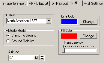
3. Fill Transparency. This option allows you to set the fill color to be opaque, partially transparent or fully transparent. Making the passage transparent allows you to see the terrain underneath.
4. Line Color. This option specifies the color of the outline around the passages. To change the color, simply press the button and choose a new color.
5. Altitude Mode. This option controls how the cave passages are attached to the earth when displayed in Google Earth. The Clamp To Ground option forces the passages to be attached directly to the surface of the ground. This may cause problem if you have other overlays like topographic maps. The cave may not be visible because it is under the topographic map. Changing the mode the "Ground Relative" and setting the Altitude so it is slightly above the ground will solve the problem.
6. Altitude. This option only applies to the "Ground Relative" mode described above. The default value is 0.1 meters, but in some instances you may need to set it higher. This is because of the curvature of the terrain and the straight-line aspects of the passages may cause some passages to sink beneath the surface.