This option displays a list of customizable shot and station data suitable for export to databases and spreadsheets. The option selectively displays a list of all stations and shots in the cave. You have the ability to control the delimiter and header and this allows you to customize the list so it can be imported by virtually any database. For example, most databases can import “coma delimited” data. Once you have created a list that meets your requirements, you can export it to a file or the clipboard.
Selecting the “Custom Export” option in the left-hand panel allows you to control which items will be exported. When you select this option an addition panel will appear with a number of options. Here is a detailed description of each item:
1. Index. Enabling this item places an index number in the list. Since Compass stores station information in the order in which is was found in the survey file, the index represents the position in the survey file.
2. Include Headers. Enabling this item places a descriptive header as the first line in the data. Each item in the header describes the corresponding column or field in the data. Some databases can use this data to construct field names. The names include no spaces, so they can even be used with databases that don’t allow spaces in their field names.
3. Include Closures. Because of the way Compass stores the processed survey data, the shots that close loops are treated separately from ordinary shots. As a result, Compass can display the the loop-closing shots separately. Enabling this item will cause the list of closing shots to be added to the end of the list.
4. From Station Name/ To Station Name. Enabling either of these items causes the corresponding station name to be included in the list.
5. From/To North, East, Vertical. Enabling any of these items puts the corresponding station location information in the list.
6. Measurements – Azimuth, Slope Length, Plan Length Inclination, LRUDs. Enabling any of these items puts the corresponding station location information in the list. Note these are calculated values and not the original values entered in the survey book. If you are working with data whose loops have been closed, the shot values may be significantly different from the original. Also, some shot may be reversed from the original values entered in the survey book because of optimization performed during processing. |
|
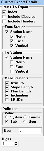
The Slope Length is length of shot as measured up or down the slope of the passage. Plan Length is the length of the shot as viewed from above. For example, if you have a 50-foot vertical shot, the Slope Length will be 50 feet but the plan length will be 0 feet.
7. Delimiter. Many programs use a particular character to separate data items. This is often called a “Delimiter.” The Export feature allows you to select either a Tab or a Coma as the delimiter. Many database can read “Coma-Delimited” text. Spreadsheets like Excel expect to see “Tab-Delimited” text.
8. Digits. This item controls the number of digits past the decimal point for numerical items.
Note: if to produce a list of unique stations in the cave, select the “To” option only and disable the Closure Shot option.