The second page allows you to see the location that you specified on a map. This makes it easy to visually verify that the locations you are entering are approximately right.
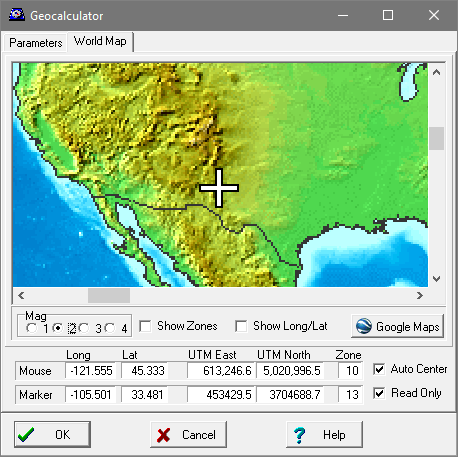
Mouse Cursor. As you move the mouse across the map, the coordinates of the cursor position will be displayed in the boxes below the map. This is useful for finding the approximate coordinates for various locations around the world.
The Marker. The geographic location you have specified on Page 1 will be marked by a “cross-shaped” cursor that appears on the map. You can move the cursor to a new location by clicking anywhere on the map. This will change Longitude and Latitude values on Page 1 and effect the Magnetic Declination calculations on Page 3. This option can be disabled to protect you from accidentally changing the value. (See below.)
Options. There are two options that control the way the map is displayed:
1. Auto Center. If this option is enabled, the program will scroll the window so that the Marker is always visible. This makes it easy to find the Marker after the position moves.
2. Read Only. When this option is selected, you clicking on the map will not change the location values. This is designed to protect you from accidentally changing the position.
3. Mag. The Mag option allows you to increase the magnification of the map for more precise reading and placement. Of course world-wide map of this scale does not have enough resolution to precisely set a cave location, but it is good enough to pick up large scale blunders.
4. Show Zone. Enabling this option draws the UTM zones on the map.
5. Show Long/Lat. Enabling this option draws the 10-degree lines of Longitude and Latitude.
6. Google Maps Button. Pressing this button will open your default web browser and take you to a Google Maps view of the location. There will be a marketer on the ground at the exact location of the current coordinate.