There are several systems that are used by cartographers to locate landmarks and terrain on the surface of the earth. Here is a description the systems that are relevant to cave cartography:
Longitude And Latitude. One of the standard systems for locating a point on the face of the earth is called longitude and latitude. The system measures the location of a point on the surface of the earth in degrees. Longitude measures the number of degrees east or west of a north/south line (meridian) that runs through Greenwich, England. Latitude measures the number of degrees north or south of the equator. |
|

Longitude and Latitude are usually displayed in Degrees, Minutes and Seconds. It is often displayed on maps with single and double quotes used to specify the minutes and seconds part:
106º 37' 30"
Longitude and Latitude can also be displayed as decimal degrees. For example:
106º 37' 30" = 106.625
Locations west of the England have negative longitudes and locations east of England have positive longitudes. Locations north of the equator have positive latitudes and locations south of the equator have negative latitudes.
Geodetic Datum. One of the problems with any measurement on the surface of the earth is the fact that the earth is not a perfect sphere. In fact, it has a lumpy pear shape to it. As a result, doing geographic calculations requires special numerical constants to compensate for the odd shape of the earth. Over the years, surveyors have gradually refined these constants to make them more and more accurate. |
|
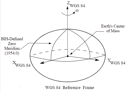
Also, some of them are specially refined for particular countries or regions. The result is that there are dozens of different constants that have been used to make maps and surveys. For this reason, different maps done at different times or in different parts of the world use different constants.
These numeric constants are called Geodetic Datum and most maps specify which datum was used to create the map. Each Datum has a name that is used to identify a specific set of constants. For example, in the United States, most maps have been created using either "North American 1927" or "North American 1983". Compass allows you to Enter, Edit or Convert Geographic References using any one of 23 standard Geodetic Constants.
Universal Transverse Mercator (UTM). While Longitude and Latitude is universally used for navigation, it is awkward for tasks like locating caves. There are several problems with Longitude/Latitude in this situation. First, while the earth is a sphere, most maps are printed on flat pieces of paper. When you project longitude and latitude lines on a flat piece of paper, it inevitably results in distortion. For example, in some projection systems, the lines will be curved. Trying to adjust a cave map to curved lines would be very awkward and confusing. Second, since the longitude/latitude system uses degrees as the unit of measure, it is hard to calculate the distance between two points.
UTM is a more useful system for locating caves because it uses a square grid of Cartesian coordinates. In order to maintain the square grid on a curved earth, UTM divides the earth into 60 narrow zones, each one six degrees wide, running north and south at right angles to the equator. Each zone is about 415 miles (668 kilometers) wide at the equator. Each zone is so narrow that the earth’s curvature has a minimal effect and a square grid can be used inside the zone. This means you don’t have to worry about mapping against curved lines. Each zone is numbered. Zones in the Northern Hemisphere are positive and zones in the Southern Hemisphere are negative. |
|
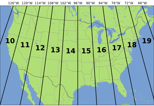
UTM coordinates are the measured distance north from the equator and east from the left edge of the zone. Thus with these two numbers and a zone number, you can specify the location of any point on earth. UTM coordinates are usually specified in meters, but occasionally they may be converted to feet.
Because, of the curvature of the earth, the zones narrow at the north and south ends.
Convergence. Because UTM places a square grid on top of a curved earth, the longitude lines will appear to curve underneath the grid. For this reason, the UTM grid lines don’t always point directly at the North Pole. "Convergence" is the amount the UTM grid is misaligned with the earth's North Pole. If you want your caves precisely aligned with UTM grid and not True North, you must rotate the cave to compensate for the convergence. Compass allows you to use the convergence angle to align a cave plot to match the UTM grid. Click here for more information about setting the convergence value. Click here for more detailed information about Convergence.