When Export3D creates Shapefiles for a cave, you have a choice of putting different types of data in the files. To choose the type of Shapefiles you want to generate, select the “Shapefiles” tab in Export3D and select the appropriate options. Here is a detailed description of each option:
I. Data Types To Convert. These options control which cave features are included in the shapefile. Normally, you select and export several different shapefile-types for each cave. This allows you to separately control and display different aspect of the cave. For example, you might want to export stations, surveys and a 3D polygon. In this way, you would view the survey line, the station locations and the passage model. |
|
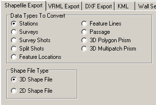
A. Stations. Selecting this option exports all the stations in the cave. Select this option if you want view the locations of survey stations.
B. Surveys. Selecting this option exports all shot in the cave, grouped as surveys. This allows you to view, label and highlight the surveys in the cave.
C. Survey Shots. Selecting this option exports all shots in the cave as individual shots. This allows you to view, label and highlight the shots in the cave.
D. Split Shots. This option splits each shot in the middle and exports the two lines for every shot. This allows the place labels at the middle of a shot, rather than at the ends.
E. Feature Location. This option exports “Compass Features” to the Shapefiles. This allows you to view special information about the attributes that might be found at each survey station. For example, if you have created a CaveBase inventory of mineral found in a cave, this option would allow you to display the location of gypsum in the cave. (See the CaveBase help files for further information.)
F. Feature Lines. This option exports “Compass Feature” as line information. This is useful for displaying routes through the cave or other linear information. (See the CaveBase help files for further information.)
G. Passage. This option exports a two-dimensional representation of the passage model. This is useful for display caves that will only be observed from above.
H. 3D Polygon/Mulitpatch Priism. These two options create a complete 3D model of the cave passage. You have the choice of representing the passage volume in either a Polygon or a Multipatch format. Although both formats represent the exact same models, some GIS programs may display these models differently. Click here for detailed information about all the 3D modeling options.
II. Shape File Type. Shapefiles can hold either 2D or 3D information. Older GIS programs only support 2D information. As a result, this option allows you to generate Shapefiles that are compatible with older programs.
III. Units. This option allows you to create Shapefile that use either meter or feet for their dimensions.