Once you have created one more survey files, you can combine them into a project. The Project Manager uses these master files to organize and process cave data. (Project Files are sometimes called "make files" because they tell the Project Manager how to “make” the project.) Project Files have the extension “MAK” and normally you would choose a name that describes the project. For example, the project for the system of caves around Wind Cave might be called “WINDSYS.MAK".
Compass displays the organization of your survey project in an easy-to-understand "tree" diagram. The tree diagram shows you all the caves, files, and surveys that makeup your project.
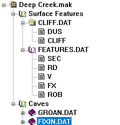
This picture shows a typical survey project. As you can see, the name of the master file (GROANSRF.MAK) is displayed at the top. The data is organized into two folders: "Surface Features" and "Caves." The individual survey files (CLIFF.DAT, FEATURES.DAT, GROAN.DAT) appear inside the corresponding folders. Finally, the individual surveys (DUS, CLIFF, SEC, RD,V, etc.) appear below the survey file name.
This particular project combines several different files related to Groaning Cave, in Colorado. The survey CLIFF.DAT, contains a surface survey that was done along the cliff face in front of the cave. The survey FEATURES.DAT contains surface features such as roads and section lines. Finally, GROAN.DAT contains the actual survey data for Groaning Cave. This particular project file combines the cave and the surface features into a single image.
One of the special features of Compass is the ability to use the same survey file in several different projects. For example, you could create another project file that also used GROAN.DAT and combined it with a different set of files. For instance, you could create a combined image of Groaning and other nearby caves.