Another common type of surveying blunder is a "bad tie-in." Bad tie-ins occur when a shot is tied to the wrong station. This can occur if you write the wrong station name in the survey book, if the station marker in the cave is mislabeled, moved or the survey renamed. Connecting a shot to the wrong station can cause very large survey errors.
The blunder detecting routines in Compass can help you locate bad tie-ins. The routine works by breaking the loop, one shot at a time. This allows each station to move to its natural location. If there is bad tie-in, the station will move near the proper connecting station. Compass then makes a connection to the nearest station and then retests the loop to see if the loop error has improved. Finally, the program records the best improvement in a list.
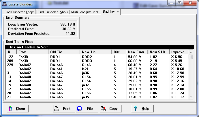
Compass analyzes Tie-ins whenever you Analyze A Loop for blunders. You can access tie-in information by selecting the "Bad Tie-Ins” page in the Blunder dialog box.
The page shows a list of the best tie-ins for the loop. The list can be sorted by specific item by clicking on the column headers. Here is a description of each column:
1. From. This item shows the original “From” station of the tying shot.
2. Old Tie. This item shows the station that was the original connection.
3. New Tie. This item shows the new connecting station that improved the loop error.
4. Diff. This items compares the old and new tie-in station names and shows how similar or different they are. Low numbers mean the two tie-ins are similar. High numbers means that are very different. This information is useful for locating blunders caused by typos.
One of the most common ways of causing is a bad tie-in is making a typo during data entry. When this happens, the correct tie-in station is generally just one or two character different from from the bad one. Tie-ins that have similar names are more likely to be blunders caused by typos.
5. New Error. This item shows what the new error would be if the new connection were used.
6. New STD. This column shows the new deviation from the predicted error level for this loop.
7. Improve. The final column shows the ratio of improvement for this connection.
If the new connection is the correct, it should dramatically improve the error in the loop. For this reason, Compass lists the 25 best fixes so you can examine the best candidates.
What To Look For. One of the most common causes of mis-ties are typos that occur while the data is being recorded or entered into the computer. For example, here are some real-world examples taken from Lechuguilla Cave data:
OLD TIE NEW TIE OLD ERROR NEW ERROR
K6 K6! 174.64 ft. 6.19 ft.
ECKJ11 ECKJ'11 152.78 ft. 1.75 ft.
BNM4 DNM4 127.52 ft. 3.44 ft.
EY52a EY52A 87.47 ft. 5.39 ft.
As you can see, mis-ties often occur because of small difference between station names.
If you see indications of a bad tie-in, carefully check the survey book to see that the shot has been correctly entered. You also may have to do an in-cave check to make sure that station haven't been moved or mislabeled.