Compass Cave Survey Software Logo - Bats, Compass and Night Sky
Custom Search
 
 Sponsored Links


COMPASS For Windows
Compass Tour
Other New Features
Cartography Tools
Live 3D Cave Images
On-line Help (New)
Written Description
Revision History: 99-21
Testimonial Letters
Contact Author
Getting COMPASS
Getting Compass
Compass On A CD.
Download/Install Issues
Installation Instructions
Antivirus Issues
Authenticating Files
False Positives
Registration Information
Credit Card Reg.
Reg. Info/Forms
Printable Reg. Form
3rd Party Reg. Form
Auxiliary Tools/Information
Cave Data
3D Glasses
ESRI/ArcView Tools
Tutorials - (New)
Inkscape Tips and Tricks
Radio Locations
Magnetic Anomalies
Installing Under Win8
Compass on A Mac
Google Earth Overlay
Declination/Convergence
Cartography Tools
Sketch Editor.
SVG Export
Inkscape SVG Maps
Illustrator SVG Maps
SVG Round Tripping
Adopting SVG Maps
Complex Plot Tutorials
Trouble Shoot CaveX
Exporting HPGL
Canvas Digital Map 
ArcView/ESRI
Italian Tutorial
Using the Compass CD
DEM Tutorial
Links
Cave Related Links
User's Pages
User's Group
User Questions
Documents/White Papers
Compass File Formats
ArcView/ESRI
Finding Blunders
Finding Loops
Loop Closure
Least Squares Papers
Least Squares Issues
Passage Modeling
Survey Blunders
J. Halleck- On Loops
History/Philosophy
SEF File Format (1992)
About The Author
COMPASS For DOS
DOS Compass Demos
DOS Compass Features
Magazine Review
MISC.
Other Products


<< Last   Top


Final Morphing

VI. Final Morph. In the final morph, we adjust the whole combined sketch-map so all the stations on the sketch match those in the line plot. Since we have already done a preliminary morph, the final adjustments will be relatively small.

A. Morphing The Combined Image. The process of doing the final morph is identical to the preliminary morph except that you are working with the combined sketch and all the shots for the whole survey. Just follow the steps in Step III. In this case, you will be working with many more stations and you may be able to enable whole surveys at once instead of just a few shots.

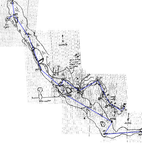
The image below shows the final morph of a portion of the Fulford B-survey. You can see by the residual grid lines how each individual image has been morphed to make it align with the survey shots.

The image has been reduced in size by about 50% and I increased the contrast so the grid lines would clearer.

B. Final Steps. When you have completed the final morph you should clean up the extraneous lines, marks, and any details that you won't need for tracing. You can do this using the Edit Tools described in step III. F. Once you are satisfied with the combined image, exit the Morph Tool by hitting the OK button and then save the image using the "Save" button.

C. Tracing and Printing. If you are tracing the image in a digital editor such as Inkscape or Illustrator, you would now load the image into that program. If you are hand-drawing your cave map, you can print the combined image to paper or a transparency and work from that. At this point, there are no print routines in the Compass sketch-map Editor, but you can load the image into Microsoft Paint (or other bitmap editor) and use it to print the image. I may add print capability later on.

<< Last

Top


 Sponsored Links
Sponsored Links
 Sponsored Links
 Sponsored Links

<< Home

Custom Search