Compass Cave Survey Software Logo - Bats, Compass and Night Sky
Custom Search
 
 Sponsored Links


COMPASS For Windows
• Compass Tour
• Other New Features
• Cartography Tools
• Live 3D Cave Images
• On-line Help (New)
• Written Description
• Revision History: 99-21
• Testimonial Letters
• Contact Author
Getting COMPASS
• Getting Compass
•Compass On A CD.
• Previous Versions  (New)
Download/Install Issues
• Installation Instructions
• Antivirus Issues
• Authenticating Files
• False Positives
Registration Information
• Credit Card Reg.
• Reg. Info/Forms
• Printable Reg. Form
• 3rd Party Reg. Form
Auxiliary Tools/Information
• Cave Data
• 3D Glasses
• ESRI/ArcView Tools
Tutorials - (New)
• Inkscape Tips and Tricks
• Radio Locations
• Magnetic Anomalies
• Installing Under Win8
• Compass on Mac/Linux
• Google Earth Overlay
• Declination/Convergence
• Cartography Tools
• Sketch Editor.
• SVG Export
• Inkscape SVG Maps
• Illustrator SVG Maps
• SVG Round Tripping
• Adopting SVG Maps
• Complex Plot Tutorials
• Trouble Shoot CaveX
• Exporting HPGL
• Canvas Digital Map 
• ArcView/ESRI
• Italian Tutorial
• Using the Compass CD
• DEM Tutorial
Links
• Cave Related Links
• User's Pages
• User's Group
• User Questions
Documents/White Papers
• Compass File Formats
• ArcView/ESRI
• Finding Blunders
• Finding Loops
• Loop Closure
• Least Squares Papers
• Least Squares Issues
• Passage Modeling
• Survey Blunders
• J. Halleck- On Loops
• History/Philosophy
• SEF File Format (1992)
• About The Author
COMPASS For DOS
• DOS Compass Demos
• DOS Compass Features
• Magazine Review
MISC.
• Betas
• Other Products


Wind Cave

This image is from the DOS COMPASS viewer. It is a display of Wind Cave in South Dakota USA. This cave is a National Park Cave. It is 76 miles long (123 kilometers), and 719 feet deep (219 meters). There are 18548 shots in the survey and 816 loops.

In this view, the cave has been rotated counter clockwise 20 degrees and tipped toward you 22 degress. In other words, you are viewing the cave from a point to the southwest, 22 degrees above the horizon. Color-by-depth has been turned on, so the cave is colored using 16 colors to indicate depth. Red is the highest and violet is the lowest.
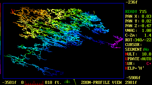
Let me explain some of the information shown in this display. The numbers at the corners of the image box are the distance from the entrance of the cave. The ruler gives the scale and the arrow shows rotation. The "flag pole" indicator just to the left of the arrow shows the pitch angle of the cave. The words "ZOOM-PROFILE VIEW" tells us that we have zoomed into the selection box and can do realtime pans, zooms and rotations. The information along the right side of the display shows the status of the display. This includes numerical values for pan, zoom and rotation, as well as survey control, measurement and clipping.

 
 Sponsored Links
Sponsored Links
 Sponsored Links
 Sponsored Links

<< Home

Custom Search