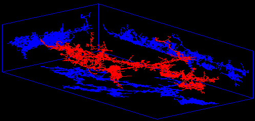
Compass Cave Survey Software Logo - Bats, Compass and Night Sky
Custom Search
 
 Sponsored Links


COMPASS For Windows
Compass Tour
Other New Features
Cartography Tools
Live 3D Cave Images
On-line Help (New)
Written Description
Revision History: 99-21
Testimonial Letters
Contact Author
Getting COMPASS
Getting Compass
Compass On A CD.
Download/Install Issues
Installation Instructions
Antivirus Issues
Authenticating Files
False Positives
Registration Information
Credit Card Reg.
Reg. Info/Forms
Printable Reg. Form
3rd Party Reg. Form
Auxiliary Tools/Information
Cave Data
3D Glasses
ESRI/ArcView Tools
Tutorials - (New)
Inkscape Tips and Tricks
Radio Locations
Magnetic Anomalies
Installing Under Win8
Compass on A Mac
Google Earth Overlay
Declination/Convergence
Cartography Tools
Sketch Editor.
SVG Export
Inkscape SVG Maps
Illustrator SVG Maps
SVG Round Tripping
Adopting SVG Maps
Complex Plot Tutorials
Trouble Shoot CaveX
Exporting HPGL
Canvas Digital Map 
ArcView/ESRI
Italian Tutorial
Using the Compass CD
DEM Tutorial
Links
Cave Related Links
User's Pages
User's Group
User Questions
Documents/White Papers
Compass File Formats
ArcView/ESRI
Finding Blunders
Finding Loops
Loop Closure
Least Squares Papers
Least Squares Issues
Passage Modeling
Survey Blunders
J. Halleck- On Loops
History/Philosophy
SEF File Format (1992)
About The Author
COMPASS For DOS
DOS Compass Demos
DOS Compass Features
Magazine Review
MISC.
Other Products


Shadow Box Images
The Viewer now has a special option that allows you to display a "Shadow Box" around the cave. With the Shadow Box options, the program draws a box around the cave and mirrors the cave on the walls of the box. The option makes it easier to see 3D aspects of the cave. The program gives lots of options for controlling which walls are mirrored and the placement of the walls.
 
Shadow Box Image of Lechuguilla Cave

Shadow Box Walls showing Grids.

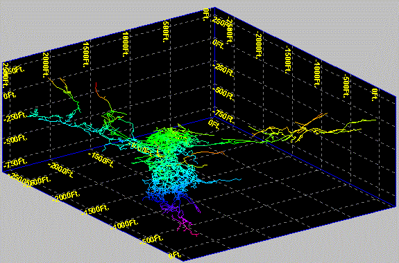
This image shows the gridding capabilities in the Shadow Box feature. Grids can be placed on any wall of the shadow box. You have complete control over the fonts, colors, line properties and spacing of the grid lines. You can specify that a certain number of lines are used or that the lines are place a certain number of feet or meters apart.
 
Lechuguilla Cave with a UTM grid superimposed.
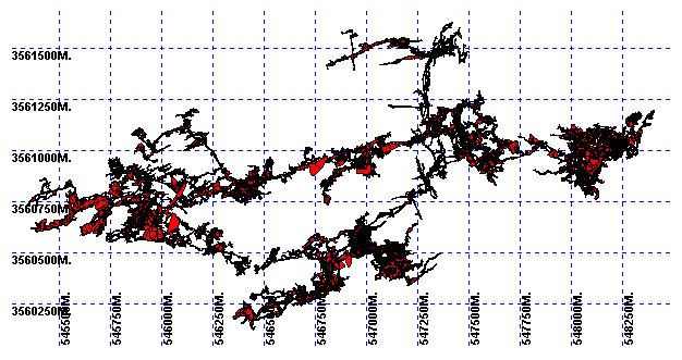
The Shadow Box walls can be removed leaving only the grids. This is useful for showing UTM and other geographic grid systems. This image show Lechuguilla Cave with a UTM grid superimposed.
 
Surface Modeling With The Shadow Box

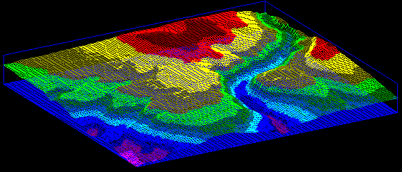
Finally, the shadow box is useful to orient and accent terrain models.
 
 Sponsored Links
Sponsored Links
 Sponsored Links
 Sponsored Links

<< Home

Custom Search