Compiling And Statistics
Compiling is the process by which COMPASS converts raw survey data into a
form that can be displayed and manipulated. In the mathematical terms, the
raw data is in polar coordinates and the process of compiling converts it
to Cartesian coordinates. The process also involves analyzing how all the
stations in the cave are connected together. The program has to be able resolve
forward references, deal with loops, and back sights. In COMPASS, shots can
be in order and the program will sort them out.
While the data is being processed, COMPASS analyzes the data for errors and
generates a number of statistics that are useful to the understanding of
the cave. COMPASS keeps track of 39 statistics and displays them in the following
window:
The statistics display is made up of seven parts. All information can be
displayed, printed, saved to a file or copied to the clipboard.
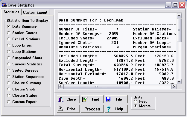
Data Summary
The data summary includes basic information like the length of the cave and
number of shots. It also includes more exotic items like the volume of the
cave and difficulty of the cave. Length measurements are displayed in meters,
feet, miles and kilometers where appropriate. Here is a sample data summary
for part of Lechuguilla Cave:
DATA SUMMARY for : Lech.mak
========================================================================
Number Of Files=        7      Station Aliases=        0
Number Of Surveys=   2055      Number Of Stations= 25798
Included Shots=     27045      Excluded Shots=       606
Ignored Shots=        231      Number Of Loops=     1849
Absolute Stations=      0      Purged Stations=        0
------------------------------------------------------------------------
Included Length=       584395.6 Feet    178123.8 Meters 110.68 Miles
Excluded Length=        18871.3 Feet      5752.0 Meters
Total Surveyed=        603266.9 Feet    183875.7 Meters 114.26 Miles
Horizontal Length=     517109.3 Feet    157614.9 Meters  97.94 Miles
Horizontal Excluded=    17617.0 Feet      5369.7 Meters
Cave Depth=              1604.2 Feet       489.0 Meters
Surface Length=         10900.1 Feet      3322.4 Meters
Surface Width=           4887.7 Feet      1489.8 Meters
Surface Area=        53276348.0 Ft^2   4949534.7 M^2
Enclosed Volume=    85466573022.7 Ft^3 2420143837.0 M^3
Cave Volume=        2752350173.1 Ft^3  77937877.6 M^3
Average Diameter=          68.6 Feet        20.9 Meters
Wall Area=          126674733.2 Ft^2  11768467.8 M^2
Floor Area=          51779254.5 Ft^2   4810450.1 M^2
Volume Density=           3.22 %
Average Inclination=     21.4 Deg.
Difficulty=              19.0
----------------------------------------------------------------------------
Highest Station=            TA34       26.3 Feet         8.0 Meters
Lowest Station=             DIVE    -1577.9 Feet      -481.0 Meters
North Most Station=         CF28      672.2 Feet       204.9 Meters
South Most Station=          JJ7    -4215.5 Feet     -1284.9 Meters
East Most Station=         MAX29     5227.3 Feet      1593.3 Meters
West Most Station=           N49    -5672.8 Feet     -1729.1 Meters
----------------------------------------------------------------------------
Average Shot Length=       21.6 Feet         6.6 Meters
Longest Shot=             216.7 Feet        66.1 Meters
Shortest Shot=              0.4 Feet         0.1 Meters
-----------------------------------------------------------------------------
|
Station Coordinates
This item lists all the survey stations in the cave and the cartesian
coordinates. This is useful for locating stations, for hand drawing maps
on a grid and for import into other programs. Here is a sample set of
coordinates:
Station COORDINATES:
Index         Station       Parent           east            north   vertical
=============================================================================
0                  F1          Ent         0.000ft         0.000ft    0.000ft
1                  F2           F1       -12.649ft       -91.038ft    4.013ft
2                  F3           F2       -56.783ft      -123.803ft    2.094ft
3                  F4           F3       -64.474ft      -182.943ft   -1.554ft
4                  F5           F4       -90.532ft      -219.597ft   -3.125ft
5                  F6           F5       -82.638ft      -283.069ft   -0.891ft
|
The coordinates are the East, North and Vertical distance from the cave entrance
or other fixed or georeferenced stations. The parent station is the first
station that connects to a station and first defines its locations.
Loop Errors
When loop fails to close, the errors indicate the cumulative quality of the
shots in the loop. Thus the loop errors are indication of the quality of
the survey and are useful for locating blunders. Here are some sample errors:
Closure Errors:
        From       To:   north     east    vert.   vector    length percent
===========================================================================
         F36      F22   3.87ft   1.37ft -10.66ft  11.43ft  113.20ft  10.09%
EXPECTED VALUES =       1.38ft   1.18ft   1.71ft   2.49ft             2.20%
STANDARD DEV.   =       2.80     1.16     6.25     4.58
---------------------------------------------------------------------------
         F41      F17   4.44ft  -3.55ft  -1.24ft  14.92ft  164.60ft   9.07%
EXPECTED VALUES =       1.31ft   2.10ft   2.40ft   3.45ft             2.09%
STANDARD DEV.   =       1.05     1.69     0.52     4.33
---------------------------------------------------------------------------
|
The error is displayed in several ways. First it is broken down into its
north, east and vertical components. This is helpful for isolating the source
of the error. For example, if the majority of the error is vertical, it implies
that the majority of the errors are in the inclination readings. Next the
error is displayed as the length of the error vector.
The most useful method of evaluating a loop is to compare it to the kind
of error you would expect to get if all the errors are random. The program
analyzes every shot in a loop and makes a prediction about the size of error
you expect to find if the errors were random. These values give the expected
standard deviation for the loop and they are Expect Values displayed above.
These values are compared with the actual values and the ratio gives the
number of standard deviations the errors represent. The higher the number,
the worse the loop. Loops that exceed two standard deviations, have a high
probability of having one or more blundered measurement.
The final number is the percentage error. This is calculated by dividing
the error by the length of the loop. For example, a one foot error in a one
hundred foot loop would give a one percent error. Percent error is a less
useful measurement of loop quality because it does not take into account
the number of shots, the quality of the instruments and the configuration
of the loop.
Loop Stations
This statistic list all the stations in each loop.
Stations Within Loops:
=======================================================================
Closure Is Between: F28A-F28
        F28A,F28B,F30G,F30F,F30E,F30D
        F30C,F30B,F30A,F30,F29,F28
        Common point: F28
	F28

Closure Is Between: FE28D-FE39
        FE28D,FE28C,FE28B,FE28A,FE28
        Common point: FE28
	FE39,FE38,FE37,FE36,FE34,FE33
        FE32,FE31,FE30,FE29,FE28
|
Loops are defined by closing shot, common point and two traverses. Each of
the stations listed above are the path that defines a particular loop. This
is information is useful for locating blunders.
Station Sequences
This statistic extracts the sequences of station names that have been used in
the cave survey. This makes it easy to find out which station names have been
used and which are available for future survey work.
		Station Sequences:
=============================================================================
Page: 1

A(10-26)Red      CB16(A-G)        CH(17-18)        CHJ(1-6)         DE(1-10)
A(1-14)          CBA(1-5)         CH(19-20)'       CHK'(1-14)       DFW(1-8)
A(15-26)Blue     CBR(1-5)         CH(20-22)        CHK'6A           DFX(1-4)
A(17-23)         CBS(1-7)         CH(2-3)'         CHP(1-6)         DFX4A
A(28-32)Blue     CBT(1-6)         CH(23-31)'       CHR(1-24)        DG(1-11)
A(28-32)Red      CBZ(1-5)         CH(3-7)          CHS(2-3)         DG(30-34)
A(34-36)Blue     CBZ1A            CH(5-8)'         CHS(2-3)A        DIVE
A(34-36)Red      cc(1-4)          CH(9-12)         CHS(4-5)'        DR(1-16)
A(4-5)Red        CC(1-6)          CH1              CHS(5-16)        DR14A
A(7-13)Blue      CD(1-12)         CH10(A-B)        CHS3B            DSM(1-11)
A1(a-b)          CE(1-17)         CH14'(C-D)       CHS5'(A-C)       DZ(1-5)
A1Blue           CE(3-4)'         CH18(A-F)        CHS6(A-B)        DZA(1-4)
A21(a-b)         CE(7-8)'         CH25             CHS8A            E(1-27)
A23A             CE3(B-G)         CH7(A-E)         CHT(1-5)         E14(A-B)
A2Red            CE3A             CH8Z             CHTA(1-21)       E2(A-B)
A5(a-f) CE3A' CHA(1-2)' CHTA6A E22(B-I) |
The option displays the base station name and the sequence associated with
it. For example if the cave contains a sequence of stations that runs from A1 to
A29, the sequence would show up in the list as A (1-29). The program can find
both numeric and alphabetic sequences and is capable of picking out the changing
part of the name even if it is in the middle of the name. It also handles
interrupted and partial sequences.
Suspended Shots
If COMPASS encounters a shot where both stations have not been previously
seen, it cannot tie the shot into the rest of the cave. Usually, these shot
will tie into the cave later after other surveys are processed. This situation
is called a Forward Reference, because the shot refers to a station that
will be defined in the future. COMPASS handles this situation by saving these
shots until later. These saved shots are called Suspended Shot and you can
display a list of all shots that were suspended during the processing of
the data. This information can be useful for reorganizing the data for optimal
processing.
Suspended Stations:
Index        From           To       From Par         To Par  Connected
==========================================================================
0            FRB5         FRC1           FRB4           FRB5        Yes
1            FRC1         FRC2           FRB5           FRC1        Yes
2            FRC2         FRC3           FRC1           FRC2        Yes
3            FR18         FRB1           FR17           FR18        Yes
4            FRB1         FRB2           FR18           FRB1        Yes
5            FRB2         FRB3           FRB1           FRB2        Yes
|
The data shows the From and To station of each shot and the "parents" of
the stations. It also shows whether the shot ultimately connected to the
cave. If a shot doesn't connect to the cave, the program will also give an
error message.
Survey Statistics
This item displays statistics for individual surveys. It shows the number
of shots in each survey, the length of the survey and the average shot length..
Surveys:
Index        Survey     Length   Shots  Ave. Len.
========================================================================
0                 F   1971.2ft      61     32.3ft
1                FA     93.0ft       3     31.0ft
2                FB    534.0ft      14     38.1ft
3                FC    283.1ft      11     25.7ft
4               FBB   1190.2ft      28     42.5ft
5                FE   1906.1ft      67     28.4ft
6               FKK   3174.7ft      60     52.9ft
|
Sorted Surveys
The final item displays an alphabetically sorted list of all surveys in the
cave. This is useful for keep track of survey names that have been used and
to keep from assigning duplicate names. It is also useful for general record
keeping.
|

